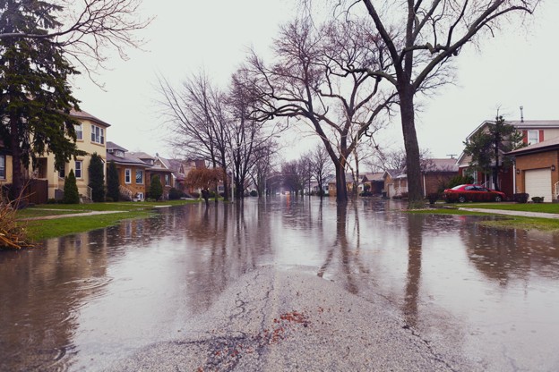
Cities are facing more flood risk today than at any point in modern history. Storms are stronger, rainfall is more intense, and urban surfaces are more paved than ever. Even a few centimetres of water can shut down intersections, flood basements, damage utilities, and overwhelm drainage systems that were never designed for current conditions.
But here’s the real challenge: You can’t model flood risk accurately without accurate terrain data.
Most cities still rely on outdated elevation sources, contour maps, coarse DEMs, or aerial imagery, that simply don’t capture the micro-topography that controls how water actually moves through a neighbourhood. A missed gutter line, a shallow depression, or a subtle road crown is all it takes to redirect water into a business, a home, or a critical facility.
This is why environmental consultants, stormwater engineers, and urban planners are turning to LiDAR as the foundation of modern drainage and flood modelling.
LiDAR gives you centimetre-level elevation accuracy, a detailed bare-earth model beneath vegetation and buildings, and the ability to map flow paths that would otherwise be invisible. For cities dealing with flood-prone river corridors, coastal zones, and fast-growing urban cores, LiDAR has become the must-have data layer for planning resilient development.
In this guide, you’ll see why LiDAR is no longer a “nice-to-have,” but the baseline for smart, defensible, climate-ready flood planning.
The Limits of Traditional Elevation Data in Urban Flood Modelling
Most elevation datasets weren’t designed for flood modelling, and that’s a big problem.
Traditional DEMs and contour-based maps smooth out exactly the features that determine where water flows:
- Road crowns
- Gutters
- Curb lines
- Depressions and sags
- Berms
- Ditch bottoms
- Parking lot slopes
- Backlot drainage paths
When these details disappear, flood models become unreliable. The result? Drainage basins get misdefined, culverts get undersized, and flood maps miss the areas most likely to be inundated.
Photogrammetry and satellite imagery have their own issues. They struggle with:
- Shadows from tall buildings
- Reflections from water
- Dense tree canopy
- Urban clutter and occlusions
- Flat areas where micro-elevation matters most
And while these methods provide a general sense of the terrain, they simply don’t offer the precision needed for floodplain modelling or stormwater planning in dense urban environments.
This is exactly why government bodies like FEMA, NOAA, and Natural Resources Canada recommend LiDAR-based DEMs as the standard for flood risk mapping. High-resolution LiDAR doesn’t just improve the accuracy of flood models; it transforms them.
Draft provincial guidance aligned with Canada’s federal flood mapping standards notes that “the Flood Risk Categories defined by the federal guidelines assume LiDAR is available or can be acquired for the project of interest,” underlining how central LiDAR has become to modern flood mapping in Canada.
When your terrain layer is correct, everything built on top of it becomes more reliable:
flood extents, water depths, flow direction, drainage capacity, mitigation priorities, and long-term infrastructure planning.
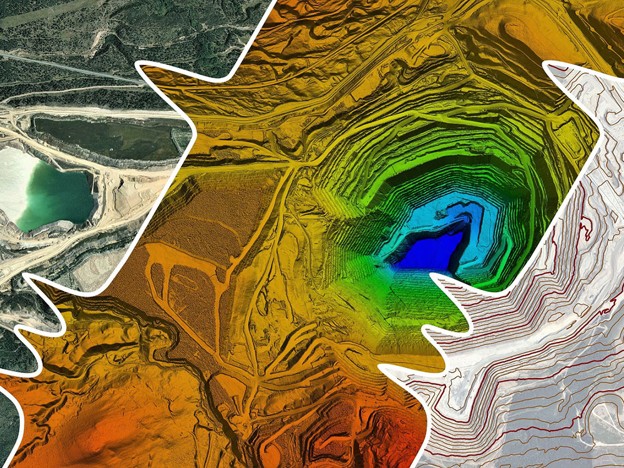
Why LiDAR Is the Gold Standard for Flood & Drainage Modelling
Flood modelling lives or dies by the quality of its elevation data, and LiDAR consistently delivers accuracy that traditional datasets can’t match. When you’re trying to understand how water moves through a city, small errors create big consequences. A five-centimetre depression can turn into a flooded street. A misread slope can direct water into a neighbourhood instead of a drainage corridor.
According to the U.S. Geological Survey’s 3D Elevation Program (3DEP), there is a “critical need for 3D elevation data for water hazard issues such as flood-damage reduction, flood risk management and flood forecasting.”
LiDAR solves this at the source by giving planners a precise, high-density picture of the ground, not an approximation of it.
A. High Vertical Accuracy (5–15 cm)
Urban drainage decisions depend on tiny elevation differences.
LiDAR’s vertical accuracy allows engineers to:
- Model realistic overland flow
- Identify low points that cause chronic ponding
- Size stormwater infrastructure correctly
- Validate where water will actually accumulate during major storms
In flat or coastal cities, this level of accuracy is non-negotiable.
B. Captures Micro-Drainage Features That Control Flooding
Flood behaviour is often shaped by subtle details that traditional DEMs smooth over. LiDAR picks up micro-features like:
- gutter lines
- curb heights
- small swales
- roadside ditches
- parking lot slopes
- subtle depressions
- alley drainage channels
These tiny elements determine whether water flows toward the storm drain, or toward a building’s foundation.
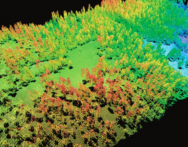
C. Creates a True Bare-Earth Surface Beneath Urban Vegetation
Trees, shrubs, and vegetation cover large portions of a city’s surface. Photogrammetry captures the canopy, not the ground. LiDAR actively penetrates vegetation, classifies ground returns, and produces a clean, bare-earth DTM that reveals true drainage pathways.
This produces far more accurate inputs for modelling tools like HEC-RAS 2D, PCSWMM, InfoDrainage, and TUFLOW.
D. Ideal for Flat and Low-Slope Urban Areas
The flatter the terrain, the more elevation accuracy matters.
Cities built on deltas, coastal plains, or glacial lakebeds can experience major flooding from just 5–10 cm of water-level variation.
LiDAR is the only practical method for creating flood-ready DEMs in low-relief environments.
E. Supports Modern 2D Flood Modelling Systems
Today’s flood modelling is overwhelmingly 2D, which means the inputs must be correct in every direction. LiDAR supports:
- full 2D inundation modelling
- pluvial (rainfall-driven) flood modelling
- riverine overflow simulations
- storm surge and wave runup modelling
- breach and overtopping scenarios
- culvert blockages and backflow events
Simply put: LiDAR gives modelers the resolution and accuracy required to simulate real-world flood behaviour, not simplified approximations.
F. Essential for Climate Resilience Planning
Cities using LiDAR are now able to:
- map the impact of intense rainfall events
- identify vulnerable intersections and underpasses
- evaluate which neighbourhoods are at highest risk
- plan green infrastructure retrofits
- prioritize capital upgrades backed by solid data
Accurate terrain = defensible flood resilience strategies.
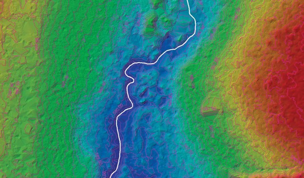
Mapping Drainage Basins With LiDAR
Drainage basins are the backbone of every stormwater plan. Get them right, and your flood modelling becomes reliable. Get them wrong, and even the most sophisticated simulation produces misleading results.
LiDAR offers the precision needed to delineate basins exactly as water sees them.
LiDAR-Derived DEMs Make Basin Delineation Accurate
With LiDAR, engineers can generate clean derivative layers:
- Flow Direction — determines where water travels
- Flow Accumulation — highlights where runoff converges
- Catchment Boundaries — identifies drainage basins
- Stream Networks — even when channels are shallow or hidden
- Depression Mapping — reveals areas of recurring ponding
- Overland Flow Paths — critical for pluvial flood modelling
This level of precision is impossible with coarse DEMs or hand-drawn contours.
LiDAR Reveals Micro-Drainage Patterns You Would Never See in Imagery
Cities are filled with tiny elevation changes that govern drainage:
- driveway slopes
- backyard swales
- failed grading around buildings
- subtle sag curves in roads
- small berms that block flow
- misaligned curbs or pavement patches
These micro-features create “unexpected” flood zones in many cities. LiDAR exposes them before they become a problem.
Better Basin Maps = Better Stormwater Design
Accurate LiDAR-based basins allow consultants to:
- size culverts and pipes correctly
- design stormwater detention and retention systems
- validate existing drainage networks
- plan upgrades based on real hydrologic behaviour
- test how extreme rainfall will move across the urban surface
This is the foundation of every stormwater master plan and the reason LiDAR has become essential for municipal drainage engineering.
Essential for Overland Flow Routing & Emergency Planning
Cities use LiDAR-derived flow paths to plan:
- emergency flood detours
- fire and ambulance access during storms
- locations for temporary barriers
- evacuation routes
- hazard zones during extreme rainfall events
For high-risk zones, LiDAR-driven basin modelling has become standard practice.
Flood Modelling Applications: Rivers, Urban Runoff, and Coastal Storm Surge
LiDAR isn’t just “better data”; it fundamentally changes how cities understand and model flood risk. Whether the threat comes from a river, a coastal storm surge, or intense rainfall overwhelming an urban system, LiDAR provides the terrain precision needed to predict what will flood, when, and why.
Below are the three major flood types where LiDAR makes the biggest impact.
A. Riverine Flooding: Accurate Floodplains Start With Accurate Terrain
River flooding is shaped by a mix of channel geometry, floodplain slope, and overbank pathways and all of these depend on having a trustworthy terrain model.
LiDAR-derived DTMs improve:
- Floodplain boundary mapping
- Riverbank elevation modelling
- Levee overtopping analysis
- Backflow and overbank flow simulations
- HEC-RAS 2D flood depth calculations
When you feed LiDAR into a hydraulic model, you get a far more reliable picture of how water will spread across a floodplain during peak flow. This is why most updated FEMA and provincial flood maps are now required to use LiDAR-based DEMs for riverine hazard assessments.
B. Urban Pluvial Flooding: Modelling Rainfall-Driven Floods at the Street Level
Pluvial flooding, flooding caused by intense rainfall rather than overflowing rivers, is becoming the fastest-growing urban flood problem worldwide.
The challenge? Pluvial flooding is controlled almost entirely by micro-topography:
- curb height
- gutter slope
- intersection depressions
- driveway grading
- backyard drainage paths
- small surface obstructions
These are features that standard DEMs smooth away. LiDAR captures them with centimetre-level precision.
Cities use LiDAR for:
- identifying flood-prone intersections
- modelling flow around buildings
- designing pluvial inundation scenarios
- locating ponding hotspots
- prioritizing stormwater and sewer upgrades
This is the type of modelling that prevents flooded underpasses, stranded vehicles, and chronic basement flooding, and it can’t be done without LiDAR-grade elevation data.
C. Coastal Flooding & Sea-Level Rise: Planning for the Real Future Shoreline
Coastal risk isn’t just about how high the water gets; it’s about how far inland it travels, how fast it moves, and which areas are overtopped first.
LiDAR supports:
- storm surge modelling
- sea-level rise projections
- king tide inundation studies
- coastal erosion mapping
- dike and seawall elevation modelling
- tsunami runup simulations
In low-lying coastal regions, even a 10 cm error in elevation can shift inundation boundaries by hundreds of metres. LiDAR is the only elevation source accurate enough to support long-term coastal planning, shoreline adaptation, and defensible flood mitigation strategies.

Infrastructure Planning: How Cities Use LiDAR for Mitigation
Flood modelling is only the first step. The real value of LiDAR shows up when cities start using that data to build resilient infrastructure.
Across North America, Australia, and Europe, municipal planners and stormwater engineers rely on LiDAR-derived hydrology layers to design smarter drainage systems and mitigate flood risk long before a storm arrives.
Here’s how LiDAR supports real-world infrastructure decisions.
Stormwater System Upgrades and Redesign
Using LiDAR-based DEMs, cities can design stormwater systems that match actual ground conditions, not estimates. This includes:
- correctly sizing culverts and pipes
- optimizing inlet placement
- designing retention/detention basins
- improving surface grading designs
- identifying failing or undersized legacy systems
When the terrain is right, the infrastructure plans are right.
Green Infrastructure & Nature-Based Solutions
Many cities are investing in green infrastructure to reduce runoff and improve water infiltration. LiDAR supports the placement and sizing of:
- bioswales
- rain gardens
- permeable pavement retrofits
- floodable parks
- wetland restoration
- urban tree canopy planning
LiDAR helps planners see which areas can naturally store water and where green solutions will have the highest impact.
Protecting Critical Facilities and Emergency Routes
Hospitals, fire halls, police stations, utility nodes, and evacuation corridors must remain accessible during storms. Cities use LiDAR to:
- identify vulnerable access routes
- map safe emergency detours
- assess which facilities sit in low points
- plan protective grading or berms
- design flood barriers around key assets
In an era of climate-driven extremes, this level of preparedness is becoming standard practice.
Capital Planning & Grant Funding Requirements
Many federal and provincial adaptation grants now require LiDAR-quality elevation models for:
- flood mitigation proposals
- drainage system upgrades
- climate adaptation plans
- stormwater master planning
- coastal resilience projects
LiDAR gives cities the defensible engineering data they need to secure funding and justify capital investments.
Real-World Examples of LiDAR Supporting Urban Flood Resilience
LiDAR isn’t just theory. Cities across North America and beyond are already using it to solve the exact problems you’re facing, chronic flooding, outdated drainage networks, and fast-changing climate risk.
Below are practical, relatable examples you can include in the blog. No fluff, just the kind of scenarios that make planners nod their heads and say, “Yes, that’s exactly what we deal with.”
Midwest River City: Updating 100-Year Flood Maps With LiDAR
A mid-sized U.S. city along a major river realized its flood maps were nearly 20 years out of date, and climate-driven peak flows had increased dramatically. Traditional contour-based DEMs weren’t capturing the true shape of the floodplain.
By switching to LiDAR-derived bare-earth models, the floodplain expanded in several critical areas, revealing:
- previously unmapped at-risk neighbourhoods
- low-elevation industrial parcels
- sensitive areas where levees were dangerously close to overtopping
The city used the updated datasets to:
- redesign portions of the levee system
- update its zoning overlays
- target grants for mitigation projects
- inform new development setbacks
The result: a flood resilience plan backed by accurate, defensible data.
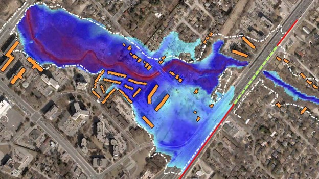
Coastal Metro Area: King Tide and Storm Surge Modelling
A coastal city facing annual king tide flooding needed more accurate elevation data for long-term sea-level rise planning. Photogrammetry smoothed over essential details like road crowns, curb lines, and small seawall gaps.
LiDAR produced a high-resolution elevation model showing:
- precise shoreline profiles
- vulnerable intersections
- low-lying stormwater outfalls
- areas where water overtopped streets and flowed inland
City planners then ran storm surge simulations using the LiDAR DEMs, leading to:
- prioritized dike upgrades
- new pumping capacity at flood-prone outfalls
- elevation requirements for new waterfront developments
- protection strategies for critical utilities
This was the city’s first flood model that actually matched observed flooding events.
Rapidly Growing Suburban Community: Chronic Pluvial Flooding from Heavy Rain
A fast-growing suburb was experiencing increasingly frequent street and basement flooding during intense summer storms. The existing DEM (based on old aerial photos) completely missed micro-drainage channels driving the problem.
LiDAR revealed:
- a series of shallow backyard swales
- a misgraded subdivision road causing water to pool
- multiple depressed lots with inadequate drainage
- ponding hotspots invisible on satellite imagery
Armed with reliable elevation data, engineers redesigned parts of the stormwater network and implemented grading corrections that dramatically reduced flooding during storm events.
Mountain Valley Town: Mapping Post-Wildfire Debris-Flow Risk
After a major wildfire, a mountain town needed to predict debris flows triggered by intense post-fire rainfall. Vegetation loss meant hydrology had completely changed.
LiDAR enabled:
- high-precision watershed delineation
- identification of new debris-flow channels
- modelling sediment-laden flash floods
- risk mapping for homes and transportation routes
This helped emergency managers issue effective evacuation plans and prioritize protective measures.
Why Cities & Consultants Choose Eagle Mapping for Flood Projects
Collecting LiDAR is one thing. Producing accurate, flood-ready data that integrates seamlessly into your modelling workflows is another.
Eagle Mapping specializes in delivering LiDAR datasets that meet the specific needs of flood modelers, stormwater engineers, and urban planners. Here’s why so many public and private-sector teams rely on us.
Precision Data Built for Hydrology & 2D Modelling
We don’t just fly LiDAR.We deliver hydrology-ready terrain models that plug directly into:
- HEC-RAS 2D
- PCSWMM
- TUFLOW
- InfoDrainage
- XPStorm
- ArcGIS Pro / QGIS
Every DEM we produce is corrected, hydro-flattened, hydro-enforced, and validated to ensure water flows accurately in your models.
Proven Expertise Across Challenging Terrain
Whether you’re working in:
- flood-prone river corridors
- low-lying coastal areas
- flat prairie landscapes
- high-relief mountain valleys
…our team has flown it, mapped it, and processed it.
Eagle Mapping has decades of experience producing engineering-grade LiDAR across North America, including some of the most complex terrain for hydrology modelling.
End-to-End Control Over the Entire Workflow
From sensor calibration to processing to hydrology modeling layers, nothing is outsourced.
This guarantees:
- consistent accuracy
- smooth data delivery
- faster turnaround times
- full accountability
- data you can trust
When a city or consultant has questions, they get answers directly from our in-house mapping specialists, not a third-party vendor.
Deliverables That Fit Your Workflow on Day One
No converting. No reformatting. No patching surfaces. Our deliverables arrive ready to use in your existing systems.
Typical data packages include:
- bare-earth LiDAR DTM
- DSM
- classified point clouds (LAS/LAZ)
- contours
- breaklines
- slope/aspect rasters
- flow direction & flow accumulation
- full hydrologic preprocessing layers
These aren’t “extras”; they’re the tools you need to model real-world flood behaviour with confidence.
A Partner for Resilience, Not Just a Data Vendor
Flood resilience isn’t solved with a single dataset. Cities need ongoing support, repeat datasets for long-term monitoring, and specialists who understand the complexities of climate-driven change.
Eagle Mapping works closely with planners, engineers, environmental consultants, and emergency managers to build LiDAR programs that support:
- capital planning
- regulatory compliance
- climate adaptation
- environmental permitting
- community risk reduction
We don’t just deliver data; we deliver clarity.
Flood Resilience Starts With the Right Elevation Data
Flood risk isn’t slowing down. Cities are seeing heavier storms, more runoff, rising water levels, and drainage systems pushed far beyond their original design. The only way to plan resilient infrastructure, and avoid costly surprises, is to start with terrain data you can trust.
LiDAR gives planners, engineers, and environmental consultants the clarity they need to understand how water actually behaves in the real world. It exposes hidden flow paths. It reveals micro-topography that traditional maps erase. And it delivers the kind of high-accuracy elevation models modern 2D flood and drainage modelling depends on.
When you build your flood strategy on top of LiDAR, everything becomes more reliable: your flood maps, your culvert sizing, your drainage upgrades, your emergency plans, and your long-term capital projects.
That’s why cities across North America are shifting to LiDAR as their new baseline, and why Eagle Mapping is the partner they trust to deliver data that stands up to real-world storms, regulatory scrutiny, and engineering demands.
If you want to reduce risk, support resilient development, and build infrastructure that lasts, start with the right data.
Use Eagle Mapping’s LiDAR data to reduce risk and support resilient development:
https://eaglemapping.com/services/