When you’re managing kilometres of powerlines, pipelines, or roads, clarity isn’t optional; it’s everything.
A few centimetres of error in clearance or elevation can mean expensive rework, safety issues, or regulatory setbacks. That’s why LiDAR corridor mapping has become the go-to solution for infrastructure and utility developers who can’t afford to guess.
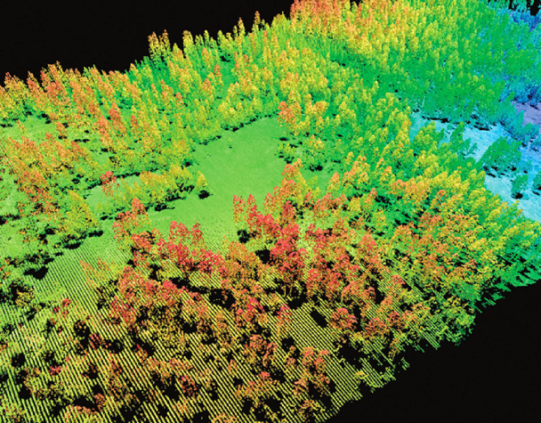
LiDAR, short for Light Detection and Ranging, captures millions of laser points per second to create a 3D “digital twin” of the landscape. It doesn’t just show what’s visible from above; it penetrates dense vegetation and reveals what’s happening under the canopy or along steep terrain. The result? An incredibly precise model of your corridor from start to finish.
Whether you’re planning a new pipeline route, inspecting transmission line clearances, or updating transportation networks, LiDAR gives you an accurate, scalable view of every metre. That’s why forward-thinking companies rely on specialists like Eagle Mapping to turn that data into actionable intelligence.
According to Rock Robotic, modern LiDAR systems can capture up to 1.2 million points per second, delivering ground-level detail with centimetre-grade accuracy, a game-changer for corridor mapping. And with Canada’s growing investment in smart infrastructure, these insights are shaping how we design, build, and maintain critical systems across the country.
Why Corridor Mapping Needs LiDAR
Corridor mapping is tough.
Traditional surveying and photogrammetry often struggle with the unique challenges of long, linear infrastructure, miles of uneven terrain, shifting vegetation, restricted access, and changing weather. Each of those factors can compromise the accuracy and reliability of your data.
LiDAR flips the script. Instead of piecing together fragments from scattered surveys, it gives you a continuous, high-density 3D dataset across the entire route.
Let’s break down what makes it so valuable:
- Unmatched precision – LiDAR systems deliver survey-grade accuracy, even in hard-to-reach terrain. A Natural Resources Canada guideline recommends 10–25 points per square metre for corridor work, enough resolution to model powerlines, poles, or roadside features in sharp detail.
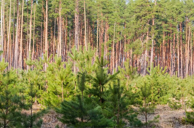
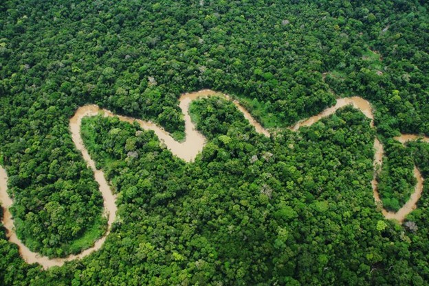
- Vegetation penetration – Unlike standard aerial imagery, LiDAR penetrates forest canopy to map both vegetation and the bare-earth terrain below, ideal for pipeline routes through wooded or mountainous regions.
- Speed and safety – By collecting massive datasets remotely (from drones, aircraft, or vehicles), LiDAR dramatically reduces the need for on-site crews and manual inspections. That means faster turnarounds, lower field costs, and safer working conditions.
- Integration-ready outputs – LiDAR data feeds directly into CAD, GIS, and engineering platforms. The output can be used for everything from route planning and clearance analysis to asset monitoring and environmental impact reporting.
As FieldGeo explains, LiDAR’s ability to cover vast corridors while maintaining millimetre-level consistency is what makes it indispensable for today’s infrastructure projects.
So, whether you’re evaluating a transmission line corridor or planning a highway expansion, LiDAR gives you something no other survey method can: a single, unified dataset that tells the whole story.
That’s the foundation of every project Eagle Mapping takes on, from powerline monitoring in rugged terrain to pipeline and roadway assessments across Western Canada.
How LiDAR Corridor Mapping Works for Powerlines, Pipelines, and Roads
Once you understand what LiDAR can do, the next question is how it actually works in practice.
Corridor mapping isn’t just about flying a drone or aircraft over a route and collecting pretty 3D visuals. It’s a strategic workflow designed to give engineers, planners, and operators the insight they need to design, maintain, and monitor infrastructure safely, from kilometres away.
Here’s what that looks like across three major applications:
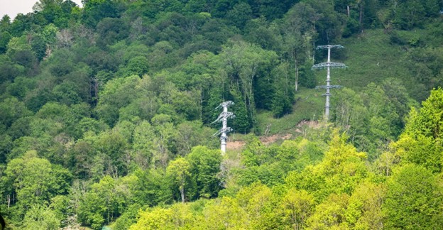
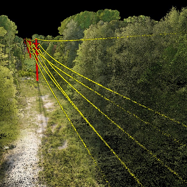
Powerlines: See Every Conductor, Every Clearance
Powerline operators face a huge challenge: ensuring proper ground and vegetation clearance along hundreds of kilometres of live transmission corridors. A single tree encroaching on a line can trigger outages or wildfires, something utilities across North America are racing to prevent.
LiDAR solves that with precise, repeatable data. Using aerial or drone-mounted LiDAR sensors, surveyors can capture tower geometry, conductor sag, and vegetation height in a single pass. The result is a detailed point cloud that can be classified into bare earth, vegetation, and structure layers, giving utilities a clear picture of what’s safe and what’s not.
According to Rock Robotic, LiDAR enables utilities to monitor line clearances to within just a few centimetres. These 3D models can be imported directly into tools like PLS-CADD or AutoCAD for clearance verification and vegetation management.
It’s not just safer; it’s faster. By using Eagle Mapping’s aerial LiDAR services, you can inspect thousands of poles in days instead of weeks, without sending crews into hazardous terrain.
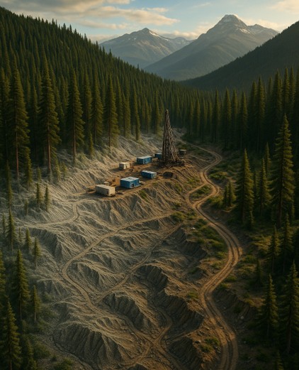
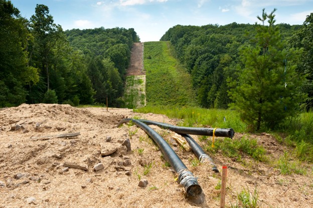
Pipelines: Map the Ground Before It Moves
When it comes to pipeline projects, terrain is everything. Slopes, river crossings, and unstable soil can all pose risks to long-term safety and compliance. LiDAR gives developers the bare-earth clarity they need to plan smarter routes and monitor changes over time.
From initial route selection to right-of-way (ROW) maintenance, LiDAR data supports every stage of the project:
- Pre-construction: Identify slope instability, drainage paths, and erosion zones before breaking ground.
- During installation: Track topography and as-built conditions for regulatory reporting.
- Post-construction: Conduct repeat LiDAR surveys to detect terrain shifts, vegetation regrowth, or potential encroachment.
A 2024 study by MDPI found that LiDAR-based elevation models improve terrain accuracy for linear infrastructure projects by over 40% compared to photogrammetry alone. That level of precision helps reduce environmental disruption, streamline permitting, and extend asset life.
Roads and Transportation Corridors: From Planning to Pavement
For road and highway projects, LiDAR data creates a digital foundation for every stage, planning, grading, design, and maintenance.
Using mobile or aerial LiDAR, engineers can build complete 3D models of road surfaces, embankments, and drainage systems. These models are crucial for detecting surface irregularities, managing right-of-way boundaries, and ensuring proper sightlines.
LiDAR also enables asset inventory, signs, guardrails, light poles, culverts, all captured automatically and geo-referenced for maintenance planning. The U.S. Federal Highway Administration notes that mobile LiDAR reduces field time by up to 70% compared to manual surveying, while improving safety by minimizing crew exposure.
Whether your corridor runs through urban density or mountain passes, Eagle Mapping’s LiDAR mapping services deliver consistency and confidence from kilometre zero to completion.
Why Infrastructure Developers and Utilities Depend on LiDAR
So, why are more developers and utilities investing in LiDAR-based corridor mapping?
Because when the stakes are high, safety, compliance, and cost, accuracy pays for itself.
Here are a few of the biggest benefits your project gains from LiDAR:
1. Accuracy You Can Build On
LiDAR provides survey-grade precision, often within 2–5 cm of ground truth. For projects that stretch across varying terrain and vegetation, that consistency is critical. The Canadian Airborne LiDAR Guidelines recommend high pulse densities specifically for corridor mapping, ensuring every pole, ditch, or slope is captured clearly.
2. Speed and Efficiency
Covering hundreds of kilometres of corridor with boots on the ground isn’t realistic anymore. With LiDAR, you can scan entire routes in a fraction of the time, often cutting survey hours by more than half. That means faster project approvals and lower field costs.
3. Better Risk and Compliance Management
Utilities can automatically detect clearance violations, vegetation encroachment, and terrain instability before they become major problems. With repeat LiDAR surveys, you can also track long-term change, from conductor sag to soil movement, and generate defensible data for regulators.
4. One Dataset, Many Uses
Unlike traditional methods, LiDAR captures everything in one pass: ground, vegetation, and structures. That single dataset can support engineering design, environmental assessments, and asset management without redundant fieldwork.
5. Safety and Accessibility
Remote sensing eliminates the need for field crews to navigate dangerous terrain or work near live utilities. It’s safer for your team and more efficient for your schedule.
As FieldGeo puts it, “LiDAR delivers a single source of truth for linear infrastructure.” That’s exactly what utilities and infrastructure teams need to plan with confidence and maintain with precision.
Key Deliverables and Outputs from LiDAR Corridor Mapping
When you invest in LiDAR, you’re not just buying data; you’re buying clarity. The power of LiDAR lies in how it transforms millions of laser points into actionable, measurable insights that engineers, planners, and asset managers can actually use.
Here’s what you can expect when you work with Eagle Mapping’s corridor LiDAR services:
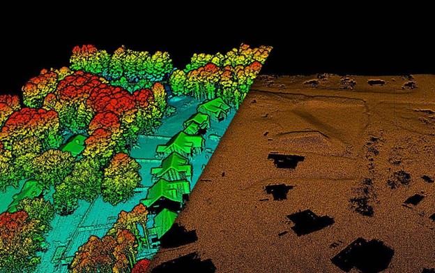
Digital Terrain & Elevation Models (DTM/DEM)
At the heart of every LiDAR survey is a detailed model of the ground.
A Digital Terrain Model (DTM) shows the bare earth, stripped of vegetation and structures, while a Digital Elevation Model (DEM) includes everything from trees to towers. Together, they create a realistic 3D foundation for route planning, slope analysis, and grading.
As noted by Natural Resources Canada, high-resolution elevation data is key to identifying flood risks, erosion zones, and drainage issues, essential for pipeline and roadway design.
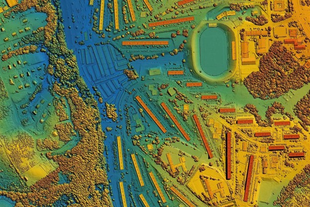
Point Clouds & Classified Data
Each LiDAR scan generates a dense “point cloud”, millions of x, y, z coordinates capturing every detail of the landscape.
At Eagle Mapping, we process and classify these points into categories such as ground, vegetation, buildings, and infrastructure. That classification allows your team to isolate and analyze only what matters: conductor clearances, vegetation encroachment, pipeline routes, or road surfaces.
Clearance & Encroachment Reports
For utilities, safety starts with clearance verification. LiDAR can accurately measure the distance between powerlines and the ground, vegetation, or nearby structures, helping operators stay compliant with safety codes and avoid outages.
According to Rock Robotic, automated clearance analysis using LiDAR data can detect potential risks months before they become violations, saving companies thousands in emergency repairs and downtime.
For pipelines, encroachment maps flag areas where vegetation or erosion might threaten stability, while for highways, they highlight potential sightline or right-of-way issues.
Cross-Sections, Profiles, and Breaklines
LiDAR corridor mapping produces cross-sectional profiles along your route, giving engineers the detailed measurements they need for cut-and-fill analysis, slope design, and drainage control. Breaklines further refine your DTM to ensure precision where it matters most, like embankments or culverts.
Asset Inventories and Change Detection
LiDAR’s greatest strength might be its repeatability. By conducting periodic scans, you can track changes over time, vegetation growth, terrain shifts, sagging conductors, or encroaching development.
This “digital twin” becomes your baseline for maintenance planning and compliance reporting, as recommended by FieldGeo’s corridor mapping framework.
Best Practices for a Successful LiDAR Corridor Project
LiDAR is only as good as the planning behind it.
To make sure your corridor mapping project delivers the insights you need, on time, on budget, and with full accuracy, here are a few best practices to follow:
1. Choose the Right Platform
Aerial, drone, or mobile? The right approach depends on your corridor type and terrain.
For example:
- Aerial LiDAR (airplane or helicopter) is ideal for long corridors such as transmission lines or pipelines through rugged terrain.
- Drone-based LiDAR works best for shorter, high-resolution segments or areas that need frequent monitoring.
- Mobile LiDAR (vehicle-mounted) is perfect for roadways or railways where surface and asset detail is critical.
2. Set the Right Resolution and Density
For corridor projects, the Federal Airborne LiDAR Guideline recommends a minimum of 10–25 pulses per square metre.
That density ensures you’ll capture everything, from conductor wires and poles to slopes and culverts, without gaps or noise.
3. Align Your Deliverables with End Use
Before the first flight, clearly define what your data will be used for.
- Will it feed into CAD design?
- Support compliance reports?
- Monitor environmental change?
Knowing this upfront allows your LiDAR provider to tailor classification, coordinate systems, and file formats (LAS, SHP, DWG, GeoTIFF, etc.) to your workflow.
4. Validate Accuracy with Ground Control Points (GCPs)
Ground control is your anchor for accuracy. Using RTK or PPK GPS reference points, LiDAR data can be georeferenced within a few centimetres of true elevation, critical for engineering and regulatory submissions.
5. Plan for Repeat Surveys
Corridors change, terrain shifts, vegetation grows, and structures settle.
Schedule follow-up LiDAR captures annually or biannually to detect subtle changes early. This is especially useful for pipelines and powerlines where small shifts can lead to major issues down the road.
6. Prioritize Safety and Compliance
One of the biggest reasons developers are adopting LiDAR is safety. Drone and aerial LiDAR minimize the need for crews to enter high-risk zones, such as steep slopes, live power corridors, or remote forests.
Incorporating Health, Safety, and Environmental (HSE) protocols during acquisition ensures both data integrity and team well-being.
7. Partner with a Trusted Provider
Finally, choose a team that knows corridor mapping inside and out.
Real-World Example: Mapping a Transmission Line Corridor
Let’s bring this to life with a real scenario.
Imagine you’re a utility company responsible for maintaining a 60-kilometre transmission line running through steep, forested terrain in British Columbia. The line crosses rivers, valleys, and wildlife corridors, the kind of environment that’s beautiful to look at but tough (and risky) to inspect manually.
Traditionally, this would take weeks of field work, multiple crews, and countless safety precautions. Even then, you’d be relying on selective spot checks, not a complete picture of the corridor.
Now, here’s what happens when you use LiDAR corridor mapping instead:
- Acquisition: Eagle Mapping deploys an aerial LiDAR system mounted on a helicopter or fixed-wing aircraft. The sensors scan the full route, collecting millions of 3D data points that capture every tower, conductor, and tree canopy along the way.
- Processing: Back at the lab, the LiDAR data is classified into layers, terrain, vegetation, structures, and conductors. The team runs clearance and encroachment analysis, identifying exact spots where vegetation is too close or where ground clearances are below standard.
- Outputs: Within days, the utility receives a full 3D corridor model, vegetation-growth maps, and compliance reports ready for their engineering software (PLS-CADD, AutoCAD, or ArcGIS).
- Results: Instead of weeks in the field, the inspection takes a fraction of the time. The company gains defensible, auditable data for regulators and a clear roadmap for maintenance priorities.
According to Rock Robotic, utilities that have switched to LiDAR for corridor management have seen up to a 50% reduction in inspection costs and a 70% improvement in vegetation management efficiency.
And because LiDAR data can be collected safely from the air, there’s zero risk to field crews, something every operations manager values.
The Eagle Mapping Advantage
When your corridor project spans hundreds of kilometres, “good enough” data isn’t good enough. You need accuracy you can trust, speed that keeps projects on schedule, and insight that helps you make the right calls long before construction begins. That’s where Eagle Mapping comes in.
We don’t just collect LiDAR; we transform it into understanding.
From aerial and drone-based mapping to ground control and QA, every dataset we deliver is built for precision, consistency, and integration into your existing engineering or GIS workflows.
When you partner with Eagle Mapping, you get:
- Survey-grade accuracy across long, linear routes
- Multi-platform capability (airborne, UAV, or mobile)
- CAD/GIS-ready deliverables for immediate use in planning and design
- Actionable intelligence, not just data, rom clearance reports to vegetation-encroachment maps
- Collaborative project management so you’re informed at every step
As Canada’s terrain becomes more challenging and infrastructure networks continue to expand, having a reliable LiDAR partner isn’t optional; it’s essential. Whether you’re mapping powerlines through the Rockies, pipelines across the prairies, or roadways through the coast, our mission is simple: help you see clearly, plan confidently, and build smarter.
And with Eagle Mapping, you get more than a map; you get a partner who understands the demands of your industry and delivers the kind of precision that keeps projects safe, efficient, and compliant.
Ready to see what LiDAR can reveal along your corridor?
Let’s talk about your corridor mapping needs. Explore our services →